
Appearance
3D Mode and Building Extrusions
Quick Answer
3D mode shows buildings as raised shapes and enables map tilt (up to 67.5°) and rotation. Choose a supported vector theme in the Base Map tab. There is no separate 3D toggle.
What Is 3D Mode?
3D mode transforms the flat map into an interactive 3D view:
- Buildings appear as extruded shapes based on actual heights
- Map can be tilted to show perspective
- Map can be rotated to any bearing
- Compass indicator appears for orientation
- More realistic visualization for site analysis
Enabling 3D Mode
Step-by-Step
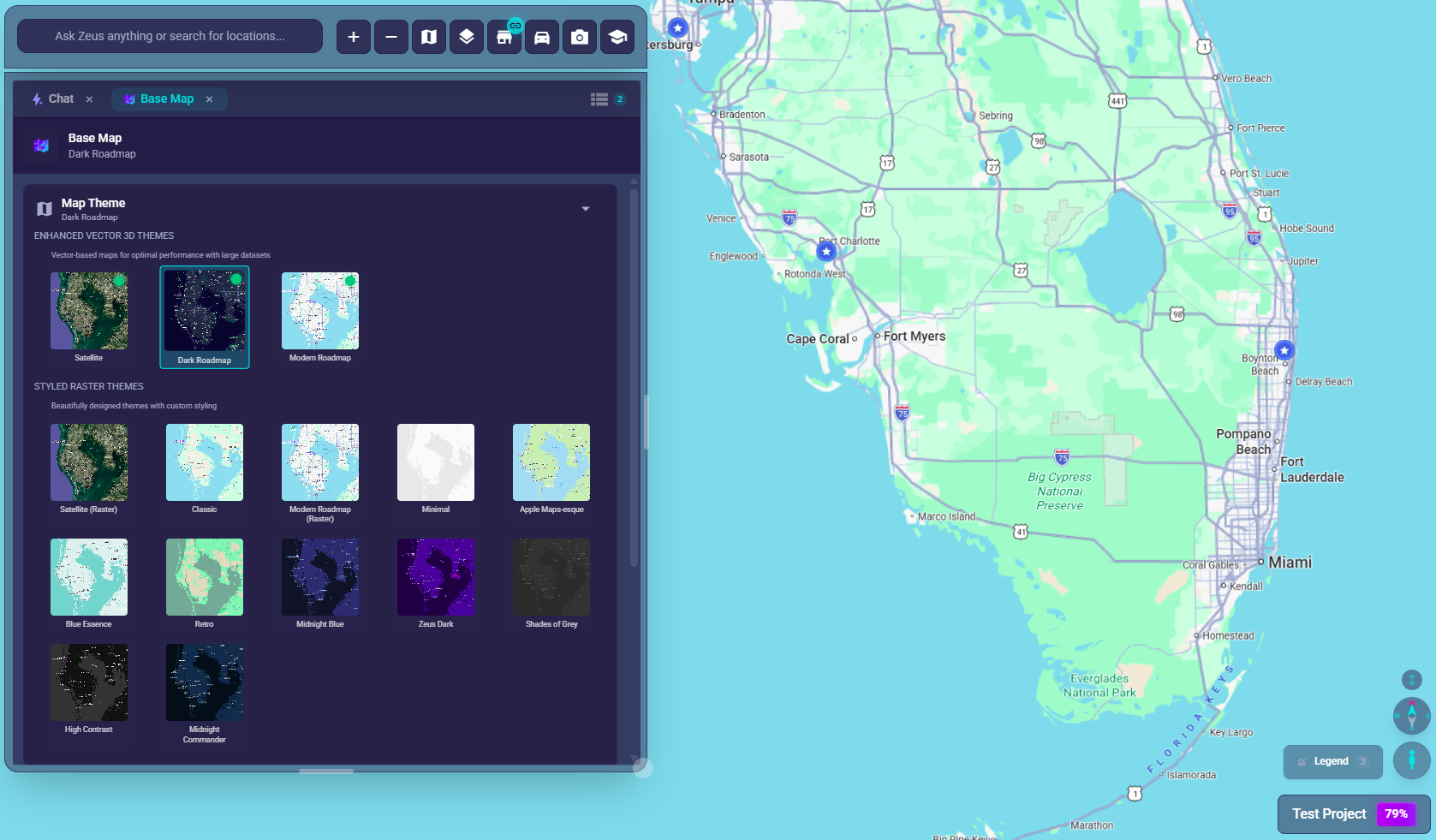
- Click the Base Map button (
map🗺️) in the chat bar at bottom-left - Choose a supported vector theme such as Satellite, Dark Roadmap, or Modern Roadmap
- 3D capability turns on automatically for supported themes
- Use the on-map compass controls to rotate or tilt when they are available
Theme Compatibility
3D Mode is available on:
- ✅ Satellite - recommended for 3D, shows buildings and satellite imagery
- ✅ Dark Roadmap - dark theme with full 3D support
- ✅ Modern Roadmap - vector theme with full 3D support
- ✅ Satellite (Raster) - full 3D support
- ❌ Classic - raster theme, no 3D
- ❌ Modern Roadmap (Raster) - raster theme, no 3D
If 3D controls are unavailable, switch to a compatible vector or satellite theme first.
3D Controls
Tilting the View
Mouse:
- Hold right-click and drag up/down
- Or hold Ctrl/Cmd and drag up/down
Touchpad/Touch:
- Two-finger swipe up/down
Tilt Range:
- Minimum: 0° (flat, top-down view)
- Maximum: 67.5° on Vector themes, 45° on Raster themes
Rotating the Map
Mouse:
- Hold right-click and drag left/right
Touchpad/Touch:
- Two-finger rotate gesture
Rotation Range:
- Full 360° rotation supported
- Compass shows current bearing
Compass Indicator
When the map is in a 3D-capable theme, a compass can appear on the map:
| Platform | Location |
|---|---|
| Desktop | Bottom-right corner of map |
| Mobile | Bottom-left corner of screen |
Compass Features:
- Shows current north direction
- Click: Rotates the map 90°
- Double-click: Resets heading to north (0°) — tilt is not affected
- Updates in real-time as you rotate
What 3D Mode Shows
Building Extrusions
- Buildings rise to their actual heights
- Taller buildings = taller extrusions
- Helps visualize urban density
Terrain
- Hills and elevation changes (on supported themes)
- More realistic landscape representation
Shadows
- Some themes show building shadows
- Indicates sun position/time of day
Use Cases
Site Verification
- Verify building heights match records
- See what's actually built vs plans
- Understand skyline impact
Visibility Analysis
- Can customers see the site from the road?
- Building shadows and obstructions
- Sign visibility considerations
Urban Context
- Downtown vs suburban character
- Building density visualization
- Surrounding development patterns
Presentations
- More visually engaging for stakeholders
- Shows real-world context
- Professional-looking screenshots
Best Practices
Optimal Viewing
| Zoom Level | 3D View Quality |
|---|---|
| Too far out | Buildings too small to see |
| Too close | Only see 1-2 buildings |
| Medium zoom | Best context and detail |
Combining with Satellite
For the most realistic view:
- Choose Satellite Vector theme
- Let the theme enable 3D automatically
- Tilt to ~45° for good perspective
- Best for verification and presentations
Saved View State
Zeus.ai saves your 3D tilt angle and compass heading with the project. When you return to a project that had a tilted or rotated 3D view, the map restores that orientation automatically -- no extra steps are needed to preserve your 3D perspective between sessions.
Performance Note
3D rendering uses more GPU resources:
- May run slower on older devices
- Turn off when not actively using 3D
- Reduce other layers if performance drops
Mobile 3D Experience
Differences on Mobile
- Compass appears top-center (below project name)
- Use two-finger gestures for tilt and rotation
- May have lower detail on mobile devices
Touch Gestures
| Gesture | Action |
|---|---|
| Two-finger drag up/down | Tilt view |
| Two-finger rotate | Rotate map |
| Pinch | Zoom in/out |
| Single tap on compass | Rotates the map 90° |
| Double-tap on compass | Resets heading to north (0°) |
Limitations
Data Availability
- 3D building data available in most urban areas
- Rural areas may lack building height data
- Quality varies by location and data source
Performance
- 3D rendering is more demanding
- May be slower on older devices
- Turn off when not needed to save resources
Accuracy
- Building heights are approximations
- New buildings may not appear yet
- Don't use for precise measurements
Troubleshooting
3D Controls Are Not Available
- You're on a non-3D-compatible theme
- Switch to a Vector or Satellite theme
- Some controls only appear after the map is in a 3D-capable state
Buildings Not Appearing
- Zoom in closer
- Check if 3D mode is actually enabled
- 3D data may not exist for that area
- Try a different location to test
Compass Not Showing
- Verify 3D mode is enabled
- Confirm you're using a 3D-capable vector or satellite theme
- May be hidden at certain zoom levels
- Check both corners of the map
View is Stuck
- Click compass to reset
- Switch to another supported theme, then switch back
- Refresh page if needed
Performance Issues
- Turn off 3D mode when not using it
- Zoom in to smaller area
- Disable other heavy layers
- Try a different browser
Keyboard Shortcuts
| Action | Shortcut |
|---|---|
| Tilt view | Ctrl/Cmd + drag up/down |
| Rotate view | Right-click + drag left/right |
| Rotate 90° | Click compass icon |
| Reset to north | Double-click compass icon |
| Enable 3D | Choose a supported vector theme |